News & Politics
Districting Commission releases draft of New York City Council maps
“Preliminary” was the key word as commissioners proposed a shakeup in southern Brooklyn and other changes in new draft City Council maps.
Draft New York City Council lines were released Friday by the city Districting Commission. Jeff Coltin - City & State


The New York City Districting Commission released its first draft map of new City Council districts on Friday, the first major step in updating the council lines after the 2020 Census.
The Districting Commission, made up of seven mayoral appointees, five appointees from the Democratic council majority and three appointees from the Republican council minority, is tasked with redrawing the 51 council districts to reflect population changes in the 2020 Census. The new maps will go into effect next February, ahead of the 2023 City Council elections.
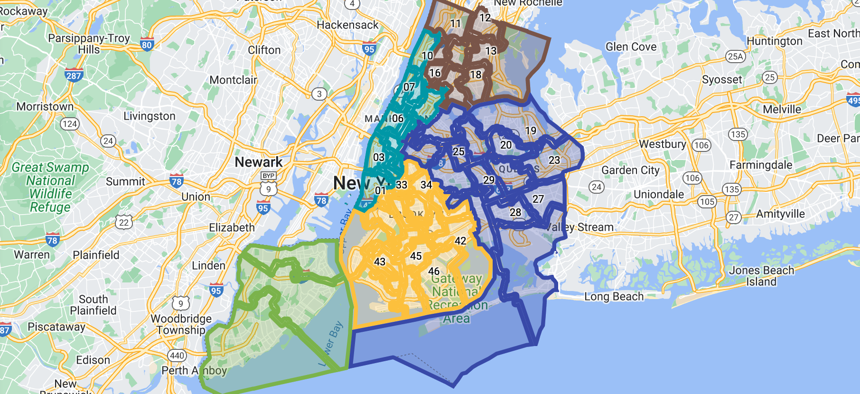
The preliminary draft map included a few notable changes across the city, such as a shakeup in southern Brooklyn creating a seat that would empower the area’s Asian American population, and the ceding of Roosevelt Island and a section of the Manhattan’s Upper East Side to the Council District 26, which is primarily in Queens. Those areas have previously been a part of Council District 5 in Manhattan.
Despite suggestions that Staten Island could see one of its three districts cross over into another borough to balance the borough’s relatively small district populations, Staten Island would retain all three districts within the borough in this draft proposal.
New York City’s population grew by roughly 630,000 people between 2010 and 2020, meaning that the average size of each City Council district has to grow too. The Districting Commission is required to draw new districts in a way that doesn’t dilute the voting power of racial and language minority groups, keeps districts compact, avoids splitting up neighborhoods and communities of interest, and limits the number of districts that cross over into more than one borough. Population changes recorded in the 2020 Census included sizable growth in the city’s Asian American and Pacific Islander population, and in the city’s Hispanic population.
Politico reported earlier this week that the commission was considering creating a new district that would empower the Asian-American population, including eastern Sunset Park and part of Dyker Heights and Bensonhurst in Brooklyn. That would also combine the western part of Sunset Park and Bay Ridge into one district, potentially pitting Council Member Justin Brannan in the current 43rd district and Council Member Alexa Avilés in the current 38th district against each other in next year’s election.
The draft map includes that new configuration for southern Brooklyn. Brannan and Avilés released a joint statement expressing disappointment with the proposal shortly after the commission voted to release the draft map on Friday. “It is perplexing that the creation of an AAPI-majority seat in southern Brooklyn would lead to the dissolution and division of Red Hook, Sunset Park – in addition to Dyker Heights – and it is certainly not necessary,” the joint statement read, noting that the 38th district is a “historically Latino” seat. “There is a better way to redistrict our City Council to best reflect the diversity of southern Brooklyn, empower new communities, and respect community borders to ensure every voter has an equal and impactful say in the way our city functions … We look forward to seeing future proposals, because this ain't it.”
Michael Schnall, a Staten Island resident and member of the Districting Commission, also raised concerns about that aspect of the map. “I think that cutting southern Brooklyn up into multiple pieces fixes a problem that doesn’t exist,” Schnall said at Friday’s hearing. “Council Districts 43, 38 and 47 are going to be turned upside down by this plan.”
Though it offers key insight into how the commission plans to approach the redrawing of districts, the map released on Friday is just a draft. Districting Commission Chair Dennis Walcott said Friday that more than 500 New Yorkers testified in person and over Zoom in hearings that preceding the release of this preliminary draft map. Another round of public hearings will be held to weigh in on this draft map before the commission submits a plan to the City Council, and commissioners urged New Yorkers to testify at those hearings starting in August. The City Council will then be able to weigh in on the next plan, but the authority to vote on and approve a final plan rests with the commission.