New York State
Want to fix the traffic problem? Tear down a freeway.
New York’s highways have decimated whole cities.
Rush hour traffic on the Brooklyn Bridge. elbud/Shutterstock

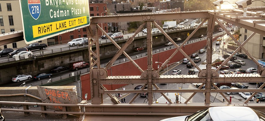
The 1.5-mile stretch of the Brooklyn-Queens Expressway in Brooklyn Heights has seen better days. On the outside, the paint is chipping, the concrete is crumbling and rust is ubiquitous. Inside, the nearly 65-year-old triple-decked section of the highway jutting from the side of the Brooklyn Heights Promenade shows wear and tear of geological proportions: “exposed rebar and stalactites made of calcium leached from the highway by years of salt spreading,” the Brooklyn Daily Eagle wrote in September during a trip inside the highway’s interior vaults. The pothole-laden roadbed is often congested with heavy traffic. Elsewhere, it has split communities like Sunset Park. It is no wonder that The New York Times in 2017 asked if the BQE was “the least-loved highway in America.”
The BQE, which is part of Interstate 278, is not the only highway in New York that has inspired anger and outrage over the years for its disruptive effects on local neighborhoods. The Sheridan, Bruckner and Cross Bronx expressways have been blamed for high asthma levels in the South Bronx. The Interstate 81 viaduct in downtown Syracuse has been called a “segregating wall” that divides poor minority residents from a vibrant university community. The Kensington Expressway transformed middle-class Buffalo neighborhoods into an isolated pocket of poverty.
How did things get this way? Robert Moses – the legendary master builder who constructed much of New York’s core infrastructure during a mid-20th century reign over the Triborough Bridge and Tunnel Authority and other obscure but influential posts – was famous for his love of highways. Even upstate cities not under his control followed his lead. Despite the controversies that often accompanied their construction, many of the public works built in the ’50s and ’60s remain valued across New York. Parks and pools are essential, and public housing has a waiting list in New York City. Bridges have an important role in a city largely made up of islands.
But highways? Their heyday may be ending. Cities across the state face a choice as the highways built 60 or 70 years ago show their age. Some lack the shoulders now required by federal highway standards, while others, like the BQE, are falling apart. These roadways could be rebuilt at great expense, but transportation planners are increasingly choosing to replace them with infrastructure that aims to revitalize urban areas, confront racial inequality – and even alleviate traffic congestion using fewer lanes.
A boulevard lined with new apartment buildings and craft breweries has replaced a section of the Inner Loop in downtown Rochester. Plans are underway to dismantle the Interstate 81 viaduct in Syracuse in order to reinvigorate downtown. The Sheridan Expressway will no longer be a limited-access interstate highway, opening up access to the waterfront in the South Bronx. “What we are doing is correcting past mistakes,” Gov. Andrew Cuomo said in 2016 when he removed a two-mile stretch of the Robert Moses Parkway, which was renamed the Niagara Scenic Parkway. The governor’s appetite for tearing down highways has evidently only increased since then, including his Sept. 17 call to remove the Buffalo Skyway.
There was no one moment or individual that changed the trajectory of state transportation planning. Instead, grassroots activists have spurred elected officials like Cuomo, who are eager to promote economic development in the state’s urban areas, to act. “There is a new generation of city and urban planners who are now moving into the upper echelons of government and you have elected officials who understand this too,” said Nick Sifuentes, executive director of the Tri-State Transportation Campaign, a nonprofit advocacy group dedicated to reducing car dependency.

Transportation planners and elected officials are also now getting ready to drive a stake into the heart of Moses’ highway legacy through a complete rethinking of a key stretch of the BQE. Its fate rests with a panel appointed by New York City Mayor Bill de Blasio that is expected to release its recommendations later this year. “It’s an extraordinary inflection point right now because the Moses-era (highway) projects are now reaching or are at the end of their functional lives just at the same time that we all know that mobility patterns (and) the technology of how we get around ... is changing so rapidly,” said Regional Plan Association President and CEO Tom Wright, a member of the BQE panel. “Whatever we do with it will set a precedent.”
The section of the BQE that the panel is analyzing is among the busiest stretches of roadway in the state – and the most complex. More than 150,000 vehicles travel through its two levels of traffic each day under the Brooklyn Heights Promenade. A 2016 study commissioned by the city Department of Transportation found that unless this part of the roadway is reconstructed by 2026, more than 15,000 trucks a day might have to be diverted onto local streets because of likely weight restrictions. The city’s original repair plan was to divert traffic to a temporary six-lane roadway where the promenade now sits while the lower expressway was built anew below. Another option would be to repair the roadway one lane at a time, which would leave the promenade open during construction but would require more time and money to complete, with frequent weekend closures.
Both of these approaches quickly became nonstarters with local community groups and elected officials. Some objected to the closing of the promenade. Others thought the renovation of the BQE provided an opportunity to fix many of the problems that the BQE brought to the neighborhood: traffic, noise, pollution and the loss of the most precious resource in New York City – space. “This project could be a rare opportunity to not just fix a dilapidated highway, but to reimagine a vital section of our city through an integrated, community-focused process that advances not just a better roadway, but a greener, more vibrant city,” New York City Comptroller Scott Stringer wrote in a March letter to city Transportation Department Commissioner Polly Trottenberg.
Just a few weeks later, de Blasio appointed the panel of experts to study alternatives to the department’s original proposals. Members of the BQE panel declined to comment on what approach they are leaning toward adopting, but it appears that the days are numbered for the current design. Panel Chairman Carlo Scissura, president and CEO of the New York Building Congress, said at a June meeting that the department’s proposal to use the promenade as a temporary highway “has very little chance of being approved.” In other words, one of Moses’ signature projects is doomed in its current form, but what will replace it?

To understand what could happen with the BQE, it’s necessary to understand what highways did to cities across the state. “Robert Moses shaped a city and its sprawling suburbs,” Robert Caro wrote in his 1974 tome “The Power Broker.” “And to an extent that would have astonished analysts of urban trends had they measured the implications of his decades of handiwork, influenced the destiny of all the cities of twentieth century America.” For upstate cities like Buffalo, Rochester and Syracuse, highways accelerated the decline of their urban cores, as middle-class, mostly white residents moved to the emerging suburbs. This sucked much of the tax base out of city governments, which then had less money to serve their remaining residents that were already suffering from the decline of the once-dominant manufacturing sector.
In 1967, the Kensington Expressway opened, replacing Buffalo’s 19th century Humboldt Parkway while providing a new connection to Rochester. State and local officials argued that building the Kensington Expressway through downtown Buffalo would more effectively relieve congestion than an alternate route along the city’s edge, selling the public on a link to the economic heart of the city. “Robert Moses, who has done such an outstanding work in New York City … rejected bypassing expressways around the edge of the city and recommended expressways through the heart of the city, as planned for Buffalo,” Buffalo City Planning Commission Chairman Welles Moot wrote at the time. Along with the construction of another expressway, the Buffalo Skyway, the Kensington Expressway achieved the opposite of its intended effects. In subsequent decades, as wealthier residents fled to the suburbs, what was once a diverse, middle-class neighborhood on what is now called the East Side of Buffalo became a poor, racially segregated enclave of African Americans. Downtown Buffalo meanwhile continued to decline.
“These highways really decimated urban cores and they did a lot to hasten the process of making these communities poor.” – Nick Sifuentes, Tri-State Transportation Campaign executive director
The construction of the I-81 viaduct in the 1950s destroyed a tight-knit black community in downtown Syracuse. Now that the 1.4-mile elevated highway is crumbling, there’s an opportunity to undo much of the damage. “There is a widespread understanding now,” Sifuentes said, “that these highways really decimated urban cores and they did a lot to hasten the process of making these communities poor, making these communities polluted and causing undue harm to the people that were removed and the people who were left.” The state Department of Transportation adopted a “community grid” plan as its preferred option in April.
The plan, championed by the New York Civil Liberties Union and other groups, will replace the viaduct with a new urban boulevard along the current route.
The community grid plan would cost about $2 billion – about half of what a tunnel would have cost to replace the viaduct. What will happen to the 100,000 cars that currently use the viaduct each day? Some local traffic would go through the boulevard, some would use other local streets and through traffic would bypass downtown Syracuse via Interstate 481 on the eastern side of the city. A draft environmental impact study released by the state Transportation Department in the spring concluded that travel times would change very little if the community grid project became reality.
The filling in of the below-grade eastern section of the Inner Loop in downtown Rochester shows what can happen to a downtown area after a city dismantles a highway. For 50 years, the circular freeway divided the city core from its surroundings, leaving anyone who lived on the inside of the loop with few ways out if they did not have a car. Hundreds of buildings were condemned and flattened and many residents moved to other areas of the city or to the newly emerging suburbs. By the end of the 20th century, the city’s population dropped by about a third from its peak of more than 300,000 residents when work on the loop began in the 1950s. “It was actually built to promote economic activity and prosperity,” Rochester Mayor Lovely Warren said. “But it really did the opposite.”
It took about 15 years and about $22 million to fill the eastern segment of the loop with mud dredged from Lake Ontario and build the new four-lane boulevard on top, with traffic signals, pedestrians crossings and lower speed limits. The removal of the highway opened up six acres of undeveloped land, sparking a resurgence in an area that was unattractive to development before the completion of the project in 2017. New housing developments have gone up to accommodate the influx of 20- and 30-something residents to the area who now frequent new coffee shops and craft breweries. “The development that has taken place and investment is really something to see,” said Robert Duffy, a former lieutenant governor and former Rochester mayor who now serves as president and CEO of the Greater Rochester Chamber of Commerce. “The areas that have been filled in right now, it is almost seamless, you would never know that the Inner Loop East even existed.” The city put out a new request for bids this summer to fill in an additional section of the loop on the northern side of downtown.

Plans to decommission highways across the state have moved forward in recent months, especially in New York City. The state is already in the midst of converting the Sheridan Expressway – a 1.3-mile stretch connecting the Bruckner Expressway and Cross Bronx Expressway in the South Bronx – into an urban boulevard that would reunite Bronx residents with the waterfront that became inaccessible when the roadway, which was once known as Interstate 895, opened in 1963. “Building the Sheridan Expressway was a mistake,” Gov. Andrew Cuomo said in 2017. “All goes back to Robert Moses.”
Originally slated for completion in spring 2019, it is unclear when the Sheridan Expressway project will be completed. A spokesman for the state Department of Transportation did not provide an expected completion date, but construction is underway on the signalized pedestrian crossings, traffic median and landscaping that will transform the at-grade interstate into an urban boulevard. Transportation advocates say that more needs to be done to better weave the new roadway into the urban fabric – but it is a start.
“Building the Sheridan Expressway was a mistake. All goes back to Robert Moses.” – Gov. Andrew Cuomo
Now, attention is also turning toward the BQE as New York City comes to grips with a concept that Moses refused to consider: No matter how many highways a city builds, or how many traffic lanes are built, congestion tends to get worse. This is because of a concept known as “induced demand.” The idea is that the more roadways you build, the more traffic you generate, because drivers will be attracted by the temporary decrease in travel time. The history of traffic mitigation in New York City is a case in point. Moses proposed his highways and bridges as ways to mitigate traffic congestion. Yet, traffic congestion increased at a much faster rate than the growth of car ownership and the city’s population after he finished major transportation projects, like the Triborough, Queensboro and Bronx-Whitestone bridges, as well as the network of roads he built throughout the downstate region.
The Embarcadero Freeway illustrates the phenomenon. More than 100,000 vehicles used the road in downtown San Francisco each day before the 1989 Loma Prieta earthquake put it out of commission. Rather than repair the elevated structure, the city eventually took it down. The move is credited with reviving the nearby waterfront, which includes a new trolley line that now carries 20,000 passengers a day along a boulevard that carries about 50,000 vehicles per day, according to a 2011 study by a University of Connecticut researcher. “Not all ‘lost San Francisco’ monuments are worth remembering,” the San Francisco Chronicle wrote in 2017 of the erstwhile “blight by the bay.”If the BQE were to lose some traffic capacity, the logic of induced demand suggests that a similar dynamic would play out: fewer people driving and more people turning toward public transportation and walking in a city with better access to the waterfront. Some highway critics cite the Embarcadero as an example of the idea that the best way to deal with a traffic-jammed highway is to just remove it entirely.
One idea for the BQE proposed by Stringer aims to reduce demand by limiting traffic on the lowest deck of the current BQE to commercial trucks – which make up one-tenth of the current traffic on this stretch of the BQE – and express buses. The deck above could then be used for pedestrians, bicycles or other uses. The proposal also calls for extending the ban on personal vehicles to an additional stretch of the highway that runs below grade in Cobble Hill and Carroll Gardens. This segment would then be covered, allowing for the construction of a new two-mile-long park on top of the current roadway from Hamilton Avenue to the Brooklyn Bridge. Through traffic to Queens could be rerouted via the Hugh Carey Tunnel and FDR Drive to the north, or the Belt Parkway to the south.
The reduction of traffic due to reduced demand would be aided by congestion pricing, which could charge drivers $12 or so to enter Manhattan below 60th Street starting in 2021. There are currently three routes to drive into Manhattan from western Brooklyn: the Hugh Carey Tunnel, the Brooklyn Bridge and the Manhattan Bridge, all of them reachable via the BQE. About 50% of eastbound drivers on the BQE at peak hours skip the tunnel – which has a toll – in favor of the bridges, which do not, according to the state Department of Transportation. About 40% of the westbound traffic comes from the bridges in the opposite direction. Assuming congestion pricing charges drivers the same amount for all three routes, drivers coming from southern Brooklyn and Staten Island will have less incentive to drive on that stretch of the BQE when they can take a shorter route through the tunnel to lower Manhattan. It is also fair to assume that traffic from Brooklyn will drop because some commuters would not want to pay tolls, especially if public transit becomes more attractive as a result of the revenue from congestion pricing.
Another plan, proposed by the Danish architecture firm Bjarke Ingels Group, would construct an underground tunnel adjacent to the current BQE, which could be repaired and transformed into parkland, housing or other uses. This approach would also allow the promenade and the two levels of highway below it to remain open during construction. It would maintain the current capacity of the BQE while improving access between Brooklyn Heights and the waterfront park below – though building traffic tunnels is much more expensive than eliminating traffic lanes. The New York City Council recently announced it would conduct its own study as well.
Given the need for commercial traffic along this route, the panel will likely recommend some type of roadway to replace the current highway. Whether it’s a truck-only route, an underground traffic tunnel or something more like what is already there, each option offers advantages and disadvantages. Given the unlikelihood at this point that the BQE would be simply rehabilitated as is, a future roadway will probably repudiate the Moses approach to city planning, which prioritized the flow of traffic over people.
It is hard to imagine that New York City would ever eliminate the hundreds of miles of highways that crisscross it. Moses wanted it to be that way and used his favorite strategy to complete projects despite opposition. “Once you sink that first stake, they’ll never make you pull it up,” he was fond of saying. The removal of highways across the state shows that it is his critics who are getting the last laugh – one expressway at a time.
NEXT STORY: Airbnb sets course for public offering