New York State
Takeaways from New York’s (competing!) redistricting draft maps
Failing to find common ground, the Independent Redistricting Commission released different plans along partisan lines.
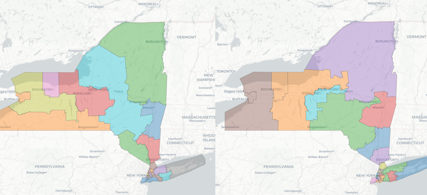
The Independent Redistricting Commission released two sets of maps along partisan lines, despite their mission to avoid partisan gerrymandering. There is a dramatic difference, for example, between the GOP version of the House district map, left, and the Democrats' version, right. The Independent Redistricting Commission

New Yorkers finally have a first glimpse at what legislative and congressional districts may look like after redistricting, and they’re seeing double. The bipartisan state Independent Redistricting Commission released two sets of draft maps on Wednesday, after failing to reach bipartisan agreement.
“We were not able to come to a consensus on a single map,” said Republican co-chair and former state Sen. Jack Martins. “I see our responsibility as a commission as putting aside partisan differences … We tried to, and unfortunately it was for naught.” The Democratic commissioners proposed and supported one set of maps – the so-called “letters” maps – while the Republicans backed the so-called “names” maps. But both sides stressed that neither set was drawn to favor one party or the other.
The New York maps will have national impact as Democrats scramble to hang onto their super-narrow majority in the U.S. House of Representatives. As states with Republican legislatures around the country redraw maps to benefit their party, all eyes are turning to New York to see whether state Democrats will change the maps to work in their favor, despite sweeping reforms approved by voters in 2014 to prevent partisan gerrymandering.
The draft maps released Wednesday are far from final, with the 10-member commission announcing 14 hearings across the state to gain input from New Yorkers about the plans. But they are a good indicator of how the process is going. Commission Chair David Imamura noted that the Commission was dealing with pandemic-related delays while analyzing Census data. “The commission has had the data … for barely a month,” he said.
The two sides had differing opinions about the dual set of maps the commission released. “I think that the fact that we put out two plans does not indicate that the commission will be unable to come to a bipartisan agreement,” Imamura told reporters. He said having both versions out in the open increases transparency, rather than having differences hashed out in “a smoked-filled zoom.” His vice chair Martins saw the situation differently. “You start out with the maps being produced separately,” Martins told reporters. “But you should end up with the maps being negotiated and presented jointly.” Martins said that Democratic commissioners did not agree to meet over the past weekend to that end.
Adding to the contention, Martins also asserted the GOP version of the map is fairer with more equitable distributions of populations, going so far as to call the other map illegal and unconstitutional. Imamura disputed that claim, asserting his party’s version is legal now, and will remain so after a ballot initiative likely gets approved in November tweaking some of the redistricting laws.
The new lines won’t go before state lawmakers for approval until early next year. At that time, Democratic supermajorities in both the state Senate and the Assembly could still overrule the commission and redraw district lines themselves. Almost as soon as she became governor, Kathy Hochul indicated that she was in favor of ensuring the maximum number of Democratic seats. And a few state senators from New York City have already said that they won’t commit to the lines drawn by the commission. “They should be considered only what they are called in the Constitution: drafts,” Imamura said of the maps.
Keeping that in mind, here are some key takeaways from the commission's many draft maps.
Maps offer vastly different visions of New York’s congressional lines
As the state prepares to lose a congressional seat, going from 27 to 26, the new lines drawn by the dueling maps would lead New York in different directions. Most differences come down to how upstate districts have been redrawn. Those are the reddest parts of the state and also the parts with the most population loss. For example, whereas Republicans kept District 23, currently held by the retiring GOP Rep. Tom Reed, mostly intact, Democrats split the district up in such a way to get more Republicans grouped together. Notably, their version puts Utica and Syracuse, both represented currently by Republicans, into one district that favors Democrats, with parts of the conservative Southern Tier connecting with right-leaning parts of the Finger Lakes instead. The GOP-backed map removes a seat from Long Island, leaving Democratic Reps. Kathleen Rice and Tom Suozzi vying for the same seat and extending Democratic Rep. Greg Meeks’ district into Nassau, while the Democrat-backed map keeps the five districts that cover Long Island with some slightly different lines.
Within New York City, the Democrat-backed draft map kept things largely as they have been for the past ten years – including the “silk stocking” district now held by Rep. Carolyn Maloney, who reportedly was hoping to off-load more progressive-leaning areas of North Brooklyn and western Queens. Whereas the Republican-backed draft would redraw the lines within the five boroughs almost entirely – except for the lone Republican-held seat, Rep. Nicole Malliotakis’ Staten Island-based district, which is drawn to stay basically the same.
Congressional District 11 stays largely the same
Whether looking at the Democrats’ or Republicans’ version of the maps, the district currently held by Rep. Nicole Malliotakis seems safe for now. Despite speculation that the lines could be redrawn to include liberal parts of Lower Manhattan instead of the conservative-leaning South Brooklyn, both maps keep the district pretty much the same. Although the maps are preliminary, this is a strong indication that the seat will remain the conservative-leaning swing district that it has been, unless Democrats in the state Legislature decide to rip up the plans and rework the lines to reach into Manhattan instead to turn the seat more Democratic.
One state Senate district for Rochester
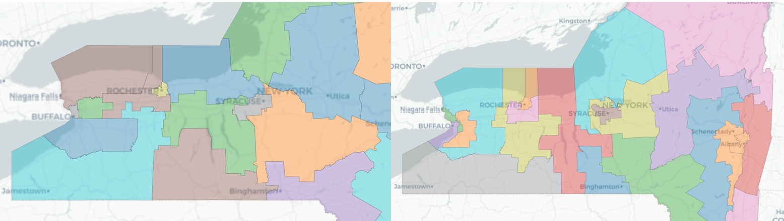
The upstate city is currently divided into three state Senate districts represented by Democrats Jeremy Cooney and Samra Brouk as well as Republican Edward Rath III. One area of similarity between the draft maps is how they would both make Rochester represented by a single district in the 63-seat chamber. Past election results suggest that Democrats will win big in the Flower City – which was represented by three Republicans as recently as 2020 – moving forward, but that could cut into potential Democratic advantages in surrounding districts. The Democratic map, however, would link left-leaning suburbs in the northeast of the city to areas on its south and southwest, which could help Brouk and Cooney avoid a tough 2022 primary to represent the city itself.
Republican commissioners might be seeking the high ground in Brooklyn
Kings County currently has some notorious gerrymanders like District 11, currently represented by Democratic state Sen. Andrew Goundardes, which is kind of shaped like a snake digesting three large mice that stretches from Bay Ridge to Jamaica Bay. A quick glance between the two draft state Senate maps shows the one backed by Republican commissioners aims to simplify the district lines significantly more than the one proposed by their Democratic colleagues. The relative continuity and compactness of the GOP draft map suggests Republicans – who controlled redistricting in the chamber last time around – are feeling a more fair-minded arrangement this time around. That makes some sense considering how Democrats have legislative supermajorities that could ultimately draw new lines as they want. Both draft maps, however, appear to be improvements on the nutty district lines that currently criss-cross the borough.
It is still too early to tell how advocacy is affecting Assembly redistricting.
Community groups were vocal at a series of public meetings about how legislative and congressional districts ought to reflect so-called communities of interest based on factors like shared geography, ethnicity or language. Queens is one of many examples of where local activists have made their voices heard to commissioners. Groups there like the Filipino community wanted to be grouped into a single Assembly district that maximizes their electoral power. The maps released by the commission Wednesday afternoon lack block-by-block details, which means we will all have to wait before we can really know how a shift of a block or two will really matter come election time.
Rep. Elise Stefanik appears safe – for now.
The North Country Republican is a rising star in the right-wing of the GOP, but her congressional career could be in danger if Democrats decide to play hardball later in the process. The map drafted by Democratic commissioners, however, keeps her district largely intact for now. Republican commissioners meanwhile have drafted a map that would significantly change her district by pushing it southwards while slicing off some western areas of the current district and linking them to areas further to the south.
What happens next?
Under the current rules, the commission needs to approve and submit maps to the state Legislature by Jan. 1, with a grace period until Jan. 15. The maps they send need approval by a bipartisan group of seven of the 10 commissioners. If they can’t reach that seven-vote threshold, they send the map with the most votes. If it’s a dead tie, they send both. The Legislature then needs to approve the maps by a two-thirds vote to send them to the governor. If the Legislature does not approve the maps, the commission has until Feb. 28 to submit new versions. If the Legislature rejects those as well, then lawmakers may draw their own maps.
A state constitutional amendment will be on the ballot in November to change the rules slightly. If approved, the commission would be required to submit their plans to lawmakers earlier, and the voting requirements for the commission to approve the plans would be relaxed. The state Legislature could need only a simple majority to approve the plans. If the commission failed to produce a consensus by Jan. 1, they would submit all their drafts to the Legislature as starting points.
With reporting by Jeff Coltin and Holly Pretsky
Correction: This article has been updated to reflect the correct details of draft boundaries for the congressional district represented by Rep. Elise Stefanik.
NEXT STORY: How do you make underground apartments safer? Many legislators and housing advocates say legalize them.