Energy & Environment
The multibillion-dollar effort to stop New York from going underwater
From the shores of Manhattan to Staten Island and Montauk Point, government is trying to prevent damage from storm surge and sea level rise.
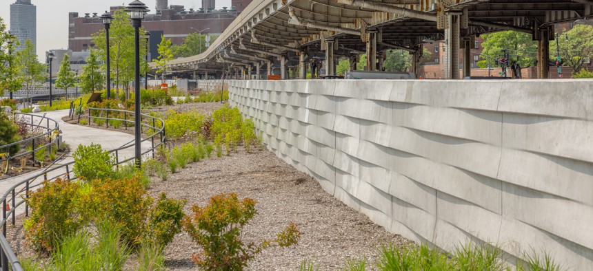
Stuyvesant Cove Park got flooding protection upgrades and reopened in 2023. Matthew Lapiska DDC

Ever since Superstorm Sandy struck New York in 2012, policymakers and politicians have been scrambling to fortify the shoreline and protect against future floods and storm surges. Some multimillion-dollar projects are underway and some are in the works, while others have been slowed by bureaucratic delays and budget cuts. Here’s a rundown of some of the biggest endeavors – in lower Manhattan, Long Island, Staten Island and elsewhere – including their price tag, lead partners and project updates.
East Side Coastal Resiliency
Price tag: $1.45 billion (including a $338 million federal grant)
Partners: New York City Department of Design and Construction, Mayor's Office of Climate & Environmental Justice and Department of Parks and Recreation
Overview: In October, New York City Mayor Eric Adams announced the completion of the first section of the East Side Coastal Resiliency project. Construction on the second, southern portion is underway and anticipated to be completed by early 2027. When fully completed, a 2.4-mile long flood barrier will stretch from East 25th Street down to Montgomery Street on Manhattan's East Side. It will feature floodwalls, berms and swinging or sliding flood gates and raised parkland, including a complete reconstruction of East River Park.

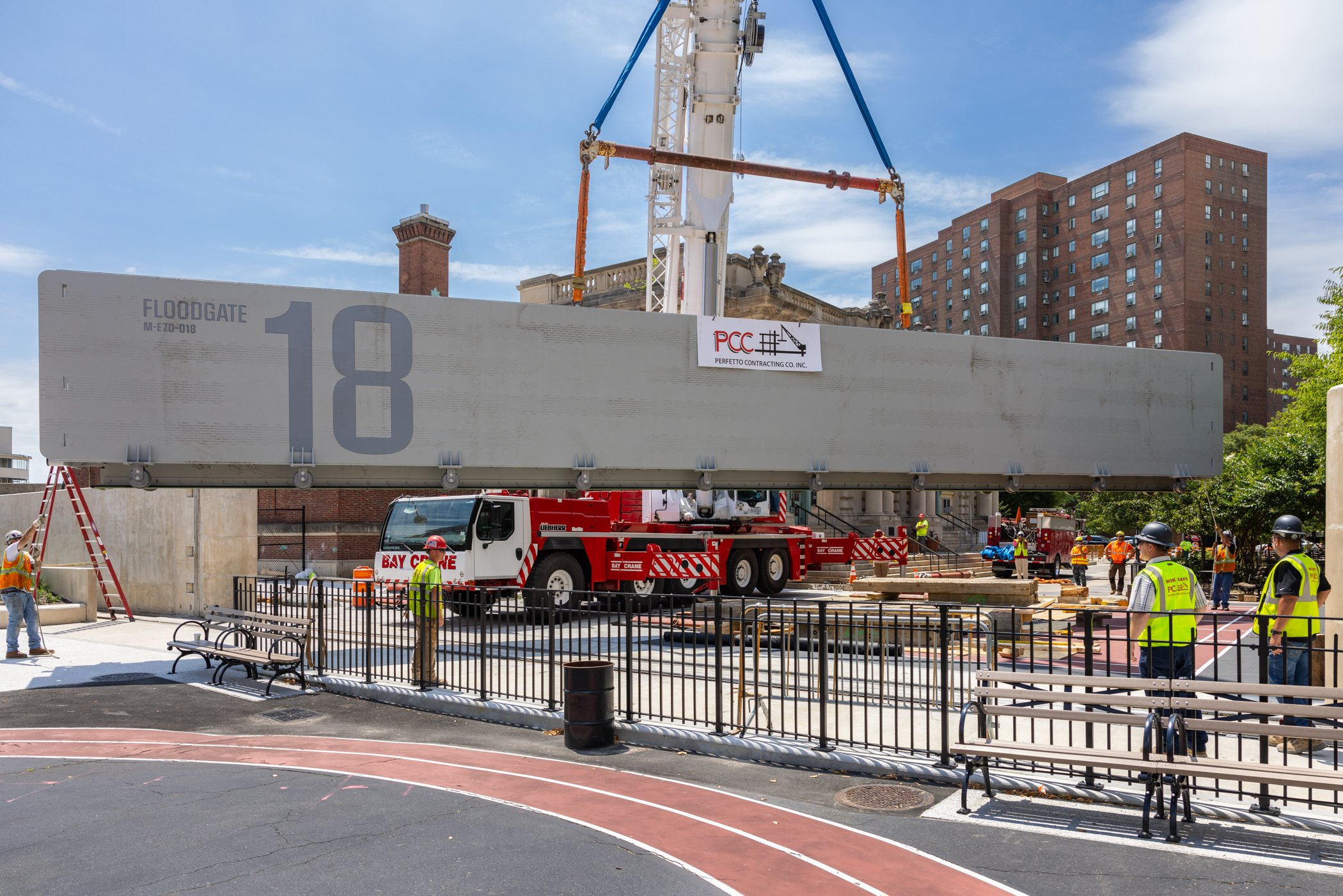
Brooklyn Bridge-Montgomery Coastal Resilience
Price tag: $350 million (including $172 million in federal funding from HUD)
Partners: New York City Department of Design and Construction, Economic Development Corporation and Mayor’s Office of Climate and Environmental Justice
Overview: A companion project to the East Side Coastal Resiliency, and directly adjoining it to the south, will be the Brooklyn Bridge-Montgomery Coastal Resilience. The flood protection project in the Two Bridges neighborhood will include deployable and permanent barriers, including flood walls and a series of flip-up gates, roller gates, swing gates and a flood door. It will extend a mile from the Brooklyn Bridge to Montgomery Street along the East River waterfront as the first phase of the 3.5-mile Lower Manhattan Coastal Resiliency initiative, and is set to be completed in 2026.
The Battery Coastal Resilience
Price tag: $200 million
Partners: New York City Economic Development Corp., Department of Parks and Recreation and the Mayor’s Office of Climate & Environmental Justice
Overview: Another key component of the Lower Manhattan Coastal Resiliency initiative is the Battery Coastal Resilience, which broke ground in the spring of 2024. The project involves rebuilding and elevating The Battery, a park in lower Manhattan, including a rebuilt wharf and promenade. It is scheduled for completion in 2027.
Battery Park City Resilience Projects
Price tags: $296 million / $1.6 billion
Partner: Battery Park City Authority
Overview: Just to the north of the Battery Coastal Resilience are additional Lower Manhattan Coastal Resiliency flood control projects. The Battery Park City Authority is spearheading the $296 million South Battery Park City Resiliency Project, which will create a flood barrier along the waterfront heading south from the Museum of Jewish Heritage Battery Park and then east into Battery Park, which it connects with the Battery Coastal Resilience. To the north, the Battery Park City Authority is planning an interconnected North & West Battery Park City Resiliency Project, at a projected cost of $1.6 billion. It will run along the Battery Park City Esplanade, cross the West Street Highway and end at Chambers and Greenwich streets. Construction is currently anticipated to begin in late 2025 and finish in late 2030.
Seaport Coastal Resilience
Price tag: $228.8 million
Partners: New York City Economic Development Corp. and the Mayor’s Office of Climate & Environmental Justice
Overview: The Seaport Coastal Resilience Project is one of the smaller projects making up the Lower Manhattan Coastal Resiliency, stretching from the Brooklyn Bridge a few blocks to John Street. The project was initially scheduled to be done by 2028, but it recently lost $42.2 million in expected federal funding when the Trump administration abruptly halted the Federal Emergency Management Agency’s Building Resilient Infrastructure and Communities program. The project aims to reduce flood risk to the Historic South Street Seaport, and overlaps in part with the larger area from the Brooklyn Bridge to the Battery covered by the FiDi and Seaport Climate Resilience Master Plan.
Red Hook Coastal Resiliency
Price tag: $157 million (including $80 million from FEMA)
Partners: New York City Department of Design and Construction, Mayor's Office of Climate & Environmental Justice, Department of Transportation, Department of Environmental Protection and the Economic Development Corp.
Overview: At the end of 2024, New York City’s Department of Design and Construction said that the Red Hook Coastal Resiliency would get underway soon. The project, which wraps around a neighborhood that was inundated during Superstorm Sandy, differs from the array of lower Manhattan flood control projects in that it protects an area that is both residential and industrial and is largely privately owned and also used for maritime purposes. The project, which will involve raising areas and adding deployable barriers, would link up with a potential U.S. Army Corps of Engineers coastal protection mega-project. It has funding lined up from New York City, FEMA and the state Division of Emergency and Homeland Services.
Alternative 3B
Price tag: $61.5 billion
Partner: U.S. Army Corps of Engineers
Overview: The U.S. Army Corps of Engineers has been developing what would be the most expansive – and expensive – flood control and storm resiliency project in the region, covering New York Harbor and various tributaries. The tentative plan, dubbed Alternative 3B, would be based on the ongoing federal New York/New Jersey Harbor & Tributaries Focus Area Feasibility Study and could also include the Hudson River as far north as Troy; several rivers in New Jersey; Jamaica Bay; the tidal straits of Kill Van Kull, Arthur Kill and the East River; and the western portion of Long Island Sound. The Army Corps of Engineers would rely entirely on federal dollars for the project, which would likely take a decade and a half to complete. However, its proposed system of massive storm gates and sea walls has drawn criticism for only focusing on temporary flooding due to major storms, and not addressing steady sea level rise. And after multiple rounds of hearings and public comment periods, the plan was scaled back significantly this summer to focus on a few immediate, short-term projects for now, including improvements along the Harlem River and at Oakwood Beach in Staten Island.

Fire Island to Montauk Point
Price tag: $1.7 billion
Partners: U.S. Army Corps of Engineers, state Department of Environmental Conservation, Suffolk County and towns of Islip, Babylon, Brookhaven, Southampton and East Hampton
Overview: The Fire Island to Montauk Point project will cover 83 miles of the south shore of Long Island and stem erosion along the coast and improve storm resiliency, with an emphasis on restoring natural beaches and barriers. The $1.7 billion construction cost would be paid by the federal government, with state and local governments tasked with maintenance. Some dredging work is already complete, and an initial construction phase of the project is scheduled to get underway in 2026.

South Shore Staten Island Coastal Storm Risk Management Project
Price tag: $615 million
Partners: U.S. Army Corps of Engineers, state Department of Environmental Conservation and New York City
Overview: Staten Island has been hammered by several major storms in recent decades, and the South Shore Staten Island Coastal Storm Risk Management Project aims to mitigate future flooding risk. The project would feature a mix of seawalls, levees and drainage structures along a seven-mile stretch from Oakwood Beach to the Verrazzano-Narrows Bridge. The federal government would cover 65% of the $615 million project, with the state covering 24.5% and the city covering the remaining 10.5%. The first construction contract was awarded last summer, and the entire project will take several years to complete.
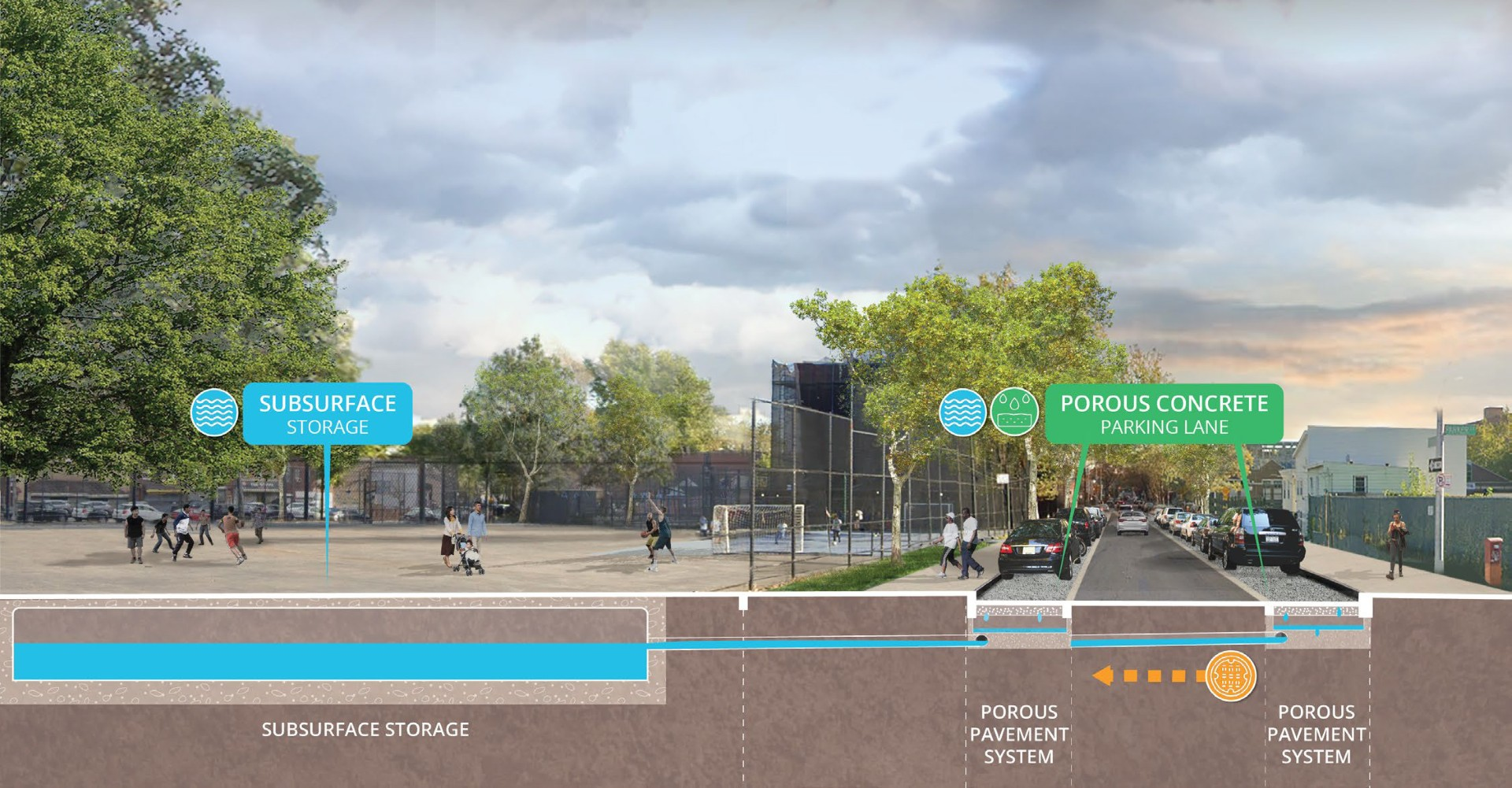
Cloudburst Hubs
Price tag: $400 million-plus
Partner: New York City Department of Environmental Protection
Overview: In recent years, New Yorkers have become familiar with cloudbursts – intense rainstorms that bring heavy amounts of rainfall in a short period of time – and New York City has been implementing systems to absorb more water during such a deluge. Following a model created in Copenhagen, the city has been creating water storage tanks, building larger sewers and replacing pavement with more porous materials, neighborhood by neighborhood. However, the federal government’s decision to suspend FEMA’s Building Resilient Infrastructure and Communities program halted some $200 million in federal funding that would’ve made up a significant share of the projects. Cloudburst hubs in Central Harlem, East Elmhurst, Kissena and Corona each lost between $46 million and $50 million in federal funding.
– with reporting by Steve Kastenbaum
Correction: This post has been updated with newer dollar figures for the Battery Park City Resilience Projects.
NEXT STORY: Penn Station gets ‘magic key’ and $43 million to push redevelopment forward